Discover the Land Speed records at Pendine Sands
This 11km-long stretch of beach is celebrated for its history of land speed records. Malcolm Campbell set the world land speed record here in Blue Bird in 1924 and again in Blue Bird II in 1927. His grandson, Don Wales’, set the electric land speed course record in 2000. And in May 2019, a Porsche 911 set a new course record of 338.50km/h. The areas you can drive on are limited now, but if you’re a petrolhead, Pendine Sands will hold a special place in your heart.
Thrill-seekers will find plenty of other adventures here that’ll raise pulses. Land yachting offers the exhilaration of travelling at speeds of over 50km/h just inches above the sand. Or you can take to the water on a sea kayak or stand-up paddle board. And if you like your horsepower more literal, feel the wind in your hair on an invigorating horse ride along the surf line.

You May Also Like
Discover the rich history of st. davids cathedral, seal spotting at cemaes head, celebrate the humble mackerel at aberaeron mackerel fiesta.
Imagine history at the Sands of Speed

The Museum of Land Speed
If you are looking for a fun, interactive and educational day out, then look no further!
The brand-new Museum of Land Speed tells the iconic story of Pendine Sands and the renowned sporting records set here, in an interactive and experiential way.
Please be aware that our exhibitions can change and that some objects, such as Babs, are only here for a few weeks of the year. If you'd like to see a particular object (even Babs!), then please call 01267 224611 (during opening hours) or email [email protected] first.

Opening Times 2024
Opening times may vary for event days.
9 April to 30 June
Open Tuesday to Sunday, 10am - 5pm.
Closing at 3pm on 30 May due to an event.
1 July - 1 September
Monday: Closed
Tuesday: 10am – 5pm
Wednesday: 10.30am – 6.30pm
Thursday: 10.30am – 6.30pm
Friday: 10am – 5pm
Saturday: 10am – 5pm
Sunday: 10am – 5pm
Open Bank Holiday Monday, 26 August, 10am - 5pm
Opening times will vary from 2 September onwards.
Any questions? Please call us: 01267 224611
Admission Prices
Day tickets and 7-day multi-site tickets are available, to give you plenty of opportunity to explore the area.
Day tickets are £7 for adults, £6 for concessions ( students and people with disabilities only), and £4 for children (age 5-18 years).
We also have a 4+ flexible day ticket, which offers 10% discount for a family or small group of four or more people.
The 7-day multi-site ticket provides unlimited visits to both the Museum of Land Speed and the Dylan Thomas Boat House in Laugharne for 7 days. Weekly tickets are £10 for adults, £9 for concessions, and £5.50 for children (age 5-18 years).
What's On
Find out about our activities and events programme at the Museum
Our latest news
Classic and sports car magazine feature.
Check out the September issue for peak inside this amazing museum!
Babs is back!
The famous world land speed record breaking car is back with us on loan until November 2024.
Find out more about Babs and Pendine here.
You'll find that the lovely article in Classic and Sports Car Magazine mentions an event this September in Pendine.
We attempted to engage interested parties in discussions to organise an event when the article was first researched. The event would have celebrated the centenary of Sir Malcolm Campbell's first land speed record in Pendine. However, for reasons beyond our control, these initial attempts did not go any further.
But there's still plenty going on here in September. Our special Amy Johnson exhibition continues and we are participating in Cadw's Open Doors month too.
There are always reasons to visit us!
About the Museum
The sands have a nearly 100-year history of setting land speed records; beginning in the 1920s with Sir Malcom Campbell and his car ‘Blue Bird’ to more recently the actor Idris Elba taking on Campbell's 'Flying Mile' record in a Bentley Continental GT Speed in 2015.
From travelling large object displays such as the legendary ‘Babs’ racing car to the interactive displays throughout, you are taken on a journey where you’ll experience the thrill and exhilaration of racing along Pendine Sands. Just close your eyes and you’ll feel the wind in your face, hear the noise of the engine and feel the movement of the car as it bumps over hidden pits in the sand.
Sounds like your kind of day out? We’ve got some more information below.
Our Exhibitions
We have plenty of exciting exhibitions for you to enjoy at the Museum. Many are interactive and great fun too!
Some of our objects come and go because they are kindly loaned to us from other institutions. Babs is one of those travelling objects, which is owned by the Babs Trust. She and other objects aren't here every day.
If you want to be sure of seeing a specific object or exhibition on your visit, then please get in touch with us first.
The location of the museum is awe-inspiring as it sits right on the edge of the famous sands. The small, beautiful Welsh village of Pendine has truly been at the heart of world records and innovation in the motoring world for a century. Find out more about how Pendine Sands featured on the world stage here: Land Speed Records | Pendine Community Council (pendinesands.org)
The Museum of Land Speed is incredibly proud to be part of the Welsh Government’s Tourism Attractor Destination programme, making it one of 13 must-see destinations across Wales. To find out more about this and other initiatives that helped bring it to life, click here:
The Museum’s first floor purpose-built function space features a huge floor to ceiling window with unparalleled views down Pendine’s seven-mile sands.
The 64m² room can be set out in boardroom style (20 pax) or theatre style (50 pax), with independent electrical blinds that easily adapt it for video conferencing, presentations, or live streaming. Its contemporary furniture, accessibility, private kitchenette, free WiFi and included AV make it suitable for a range of functions. Refreshments can be served in the room, or you can pre-order lunch to be served in the Caban restaurant.
We can work with you to create the perfect event. Contact us to discuss your requirements on [email protected] or fill out the contact form
CofGâr and the Museum of Land Speed are conscious of the environmental implications of motoring. Our environmental goals to be a carbon neutral local authority by 2030 will mean our focus is on the future as well as the past. The highly efficient museum building designed to reduce carbon emissions is a fitting place to explore the future of the car and mobility through partnerships, special exhibitions, and events.
Museum of Land Speed, Marsh Road, Pendine. Sat Nav: SA33 4NY. The Museum is by the sea, close to Pendine village centre.
Parking & Transport
Pay and display car parks are located close to the museum with EV charging points. Parking on the beach is also available (subject to tides).
Secure bike containers are available to hire on site and bike shelters are also available free of charge.
The museum is on a public bus route, with daily services to Carmarthen (number 222) and Tenby via Saundersfoot (no. 351) operated by Taf Valley Coaches.
The nearest train stations to the museum are at Whitland (approx. 10 miles), Tenby (approx. 17 miles), and Carmarthen (approx. 18 miles)
Accessible WCs and a Changing Places Toilet in the Museum and Caban.
Lockers for your belongings in the museum.
Museum gift shop.
Play area and picnic benches outside the museum main entrance.
Accessible access to the beach promenade and the famous 7-mile beach.
Several places to eat close to the museum. The Caban restaurant is right next door https://cabanpendine.wales/
Day tickets are £7 for adults, £6 for concessions ( students and people with disabilities only), and £4 for children (age 5-18 years). We also have a 4+ flexible day ticket, which offers 10% discount for a family or small group of four or more people.
The 7-day multi-site ticket provides unlimited visits to both the Museum of Land Speed and the Dylan Thomas Boat House in Laugharne for 7 days. Weekly tickets are £10 for adults, £9 for concessions, and £5.50 for children (age 5-18 years).
Terms & Conditions
Children under 5 are free.
Concessions apply to students (with valid student card) and people with a disability.
Free entry to carers when supporting a visit by the person you care for.

Welcome to the future
It's been a long haul across three years, with major challenges, but the Museum of Land Speed is now complete.

Pendine and Speed
For a short time, for a few people, Pendine Sands was the centre of the world. The centre of the World Land Speed Record to be precise.

Carmarthenshire Museum
Discover Carmarthenshire’s story in the wonderful surroundings of the historical palace and gardens of the bishops of St. Davids, Abergwili.

Dylan Thomas Boathouse
Discover the iconic home and Writing Shed of Dylan Thomas where the poet experienced a creative renaissance

Parc Howard Museum
Discover the heart of Llanelli with stories of the town’s industrial past as well as an extensive collection of the area’s famous pottery.

Kidwelly Industrial Museum
Famed for its local castle, Kidwelly is also home to the oldest tinplate works in Europe. Currently closed to the public, you can follow news of development at this historic place here.
Abergwili SA31 2JG
Felinfoel Road Llanelli SA15 2LJ
Pendine SA33 4NY
Kidwelly SA17 4LW
Laugharne, SA33 4SD
|
|
| BABS 15 August 2011 - The Bluebird electric car, driven by Sir Malcolm Campbell's great-grandson Joe Wales, in a failed attempt to set a British speed record in an electric car Photo taken in 1924, Malcolm Campbell is pictured at Pendine Sands, South Wales, Great Britain in his new Sunbeam which had 550 Horse Power. He set a new record by driving his new Blue Bird at 146.2 MPH (233.86 KPH). On February 4, 1927, once again at Pendine Sands in England, Sir Malcolm set another International land speed record. This time he achieved 174.88 MPH (279.81 KPH), in his Bluebird Napier-Lion which had 12 cylinders and 450 Horse Power. The attempt by Guilio Foresti on the Land Speed Record at Pendine Sands on 26th November 1927. Miraculously, Foresti survived. This book is an illustrated account of Bob Berry's attempts at breaking the World Land Speed Record on Pendine Sands, 1946-60 PENDINE, on the sands between 1924 and 1927 the worlds land speed record was broken 5 times 1924, Malcom Campbell, Sunbeam, 146.16 mph 1926, Malcolm Campbell, Sunbeam, 150.87 mph 1926, J.G.P. Thomas, Thomas (BABS), 169.30 mph 1926, J.G.P. Thomas, Thomas (BABS), 171.02 mph 1927, Malcolm Campbell, Napier Campbell, 174.88 mph Parry Thomas was killed at Pendine on March 3rd 1927 whilst attempting to regain the record. His friends then buried the car in the sand dunes. (photo 2003) | |||||||||||||||||||||||||||||||||||||||||||||||||||||||||||||||||||||||||||||||||||||||||||||||||||||||||
Pendine Sands is a 7-mile (11 km) length of beach on the shores of Carmarthen Bay on the south coast of Wales. It stretches from Gilman Point in the west to Laugharne Sands in the east. The village of Pendine is situated near the western end of Pendine Sands. In the early 1900s the sands were used as a venue for car and motor cycle races. From 1922 the annual Welsh TT motor cycle event was held at Pendine Sands. The firm flat surface of the beach created a race track that was straighter and smoother than many major roads of the time. Motor Cycle magazine described the sands as "The finest natural speedway imaginable". In the 1920s it became clear that roads and race tracks were no longer adequate venues for attempts on the world land speed record. As record breaking speeds approached 150 mph (240 km/h), the requirements for acceleration to top speed before the measured mile and safe braking distance afterwards meant that a smooth, flat, straight surface of at least 5 miles (8.0 km) in length was needed. The first person to use Pendine Sands for a world land speed record attempt was . On September 25, 1924 he set a world land speed record of 146.16 mph (235.22 km/h) on Pendine Sands in his . Four other record breaking runs were made on Pendine Sands between 1924 and 1927; two more by Campbell, and two by Welshman in his car . The 150 mph (240 km/h) barrier was decisively broken, and Campbell raised the record to 174.22 mph (280.38 km/h) in February 1927 with his second Blue Bird. On March 3, 1927 Parry-Thomas attempted to beat Campbell's record. On his final run while travelling at about 170 mph (270 km/h) the exposed drive chain broke and partially decapitated him; Babs went out of control and rolled over. Parry-Thomas was the first driver to be killed during a world land speed record attempt. This was the final world land speed record attempt made at Pendine Sands. Parry-Thomas' car Babs was buried in the sand dunes near the village of Pendine. In 1969 Owen Wyn Owen, an engineering lecturer from Bangor Technical College, sought and received permission to excavate Babs. Over the next 15 years he restored the car, which is now housed in the Museum of Speed in Pendine village. In 1933 Amy Johnson and her husband, Jim Mollison, took off from Pendine Sands in De Havilland DH.84 Dragon G-ACCV 'Seafarer' to fly non-stop to New York. Blown off course, they landed down-wind in the dark at Bridgeport, Connecticut after flying for 39 hours over a distance of 3,300 miles at an average speed of 85 mph, overshot, and were both seriously injured in the crash. During the Second World War the Ministry of Defence acquired Pendine Sands and used it as a firing range. The beach is still owned by the Ministry of Defence; prominent signs warn of the dangers of unexploded munitions and public access is restricted. Monday to Friday part of the beach is closed off because of MOD operations. In June 2000 Don Wales, grandson of and nephew of , set the United Kingdom electric land speed record at Pendine Sands in Bluebird Electric 2, achieving a speed of 137 mph (220 km/h). Top Gear filmed a review as part of the fifth episode of their fourth season, and returned to film a second review for the first episode of the fifth season. Scrapheap Challenge used the beach as the venue for the challenge in Season 10, Episode 1, aired in 2008. Today Pendine Sands is sometimes used as a stage in rally car events, although spectator access is limited for safety reasons. It is also a popular venue for kite buggying and homebuilt hovercraft. Between 9 July 2004 and May 2010 all vehicles were banned from using Pendine due to safety concerns, however since May 2010 cars have again been allowed access.
External links
The Museum of Speed in Pendine, CarmarthenshireThe Museum of Speed in Pendine was opened in 1996. The museum focuses on the use of the sands at Pendine for land speed attempts and racing. The main exhibit for the summer season is ' Babs ', the motor car used by Parry Thomas on his fatal attempt at the record in 1927. Other record breaking and fast vehicles can be seen at other times. Carmarthenshire Land Sailing Club - CLSCWelcome to carmarthenshire land sailing club. CLSC exists to promote and maintain access for land sailing, including land traction kiting activities, on Cefn Sidan (Pembrey) and Pendine beaches. As part of the access agreement, everyone taking part in these activities on these beaches must be a member of CLSC. Our goal is to promote and enjoy all types of kite flying, land yachting and other land sailing activities, including one-liners, stunt, kite boarding, kite buggying and kite surfing. We are a friendly, open club willing to help new comers to our sport develop their skills. To assist with this, we have a number of nationally qualified Kite Instructors within our membership. Things We Do:Nam liber tempor cumuod soluta nobis eleifend option congue imperdiet doming id quod mazim placerat. Lorem ipsum dolor amet, consectetuer adipiscing elitom nonummy nibh euismod tincidunt ut laoreet dolore magna. Ut wisi enim ad minim veniam, quis nostrd exerci tation ullamcorper suscipit lobortis nisl ut aliquip. Accessibility optionsColour variations, enlarging images. When viewing a Venue, all of the thumbnails can be enlarged by clicking on them. On mobile devices you can also zoom in further using touch gestures (pinch with two fingers to zoom in and out). Map Options
Pendine, Carmarthenshire. Open at all times. Free entry. Accessibility: There are two car parks in Pendine - one on Marsh Road and one on the sea front. The latter is pay and display with blue badge holders getting an hour of free parking once a ticket has been purchased. The sea front car park has two disability spaces and is next to the toilet block, which also has disability facilities. The area is generally well-paved and the sea front is quite flat. Many of the premises are single storey with level access, but not all of them. There are ramps down to the beach which is relatively firm sand. Brief Description: Pendine is a village of two parts. The original settlement sits around the parish church 400 metres uphill from the coast. as well as the settlement around the harbour, which has grown during the 20th century and now also includes caravan parks, cafes and beach front facilities. The latter is most famous for Pendine Sands, home of many Land Speed Records and attempts, including those of Malcolm Campbell and J. G. Parry-Thomas. Pendine Museum of Speed is still the summer home of the restored 'Babs', which Parry-Thomas drove to a land speed record on the sands in 1926 and in which he died in a subsequent failed attempt the following year. Some of the beach is used as a military firing range, land-sailing, kite buggying and even a test site for the latest Thrust SSC world land speed record attempt car. Further Information: Pendine, Carmarthenshire, SA33 4PF Chris Delaney, Clerk, Pendine Community Council: [email protected] Community council: http://www.pendinesands.org/ https://www.bbc.co.uk/news/articles/c98qnr5ywqvo Online e-mail form: http://www.pendinesands.org/contact-us/#.WgZLSWi0O00 Opening Hours: Open at all times. Free entry. Parking charges may apply. Directions: From Carmarthen follow the A40 for about 9 miles to the A477 in St Clears. At the roundabout take the first exit onto the A477 and follow this road for around 6.5 miles to Red Roses and take the slip road on the left. This road doubles back on itself up to a cross roads with the B4314 next to a public house and caravan park. Turn right towards Pendine. Follow this road to the sea front at Pendine (about 4.5 miles). OS SN233079 Pendine is serviced by the 222 bus service: https://bustimes.org.uk/services/222-pendine-carmarthen For more travel information go to https://www.traveline.info/ or call 0871 200 22 33. There are cafes, public houses, diners and shops in the sea front area of Pendine. Nearest Venues [toilets] Pendine Public Toilet Block 201 metres*  Museum of Speed, Pendine, Carmarthenshire. See link in listing for seasonal open days. Entry fee may apply. 255 metres*  St Margaret's Church, Pendine, Carmarthenshire. Grounds open daily. Free entry. For services see listing. 984 metres*  Eglwys Gymyn. St Margaret's Church. Open daily. Free entry. 1.72 miles*  Marros. St Lawrence Church. Open daily. Free entry. 1.74 miles*  Marros, Carmarthenshire 1.75 miles* *Distances are calculated in a straight line from the current venue, please allow extra time/distance based on available paths or roads. Carmarthen Bay Walkthrough: Pendine to Laugharne to Llansteffan Home » The Walking Blog » Carmarthen Bay Walkthrough: Pendine to Laugharne to Llansteffan I’d hit what must of been the half-way mark when I noticed there was no-one around for miles. Out in front, there was sand… after sand…and I could just about glimpse Dolwen Point looking back over my shoulder. Otherwise, nothing. By the mid-way point I’d felt as if I’d settled, that restless feeling that so often clings for the first few miles is now lost – this is a perfect landscape to lose yourself in. Not to put too fine a point on it, but a quiet moment of reflection, out in the fresh air – can really work wonders.  Pendine Sands is a flat out seven miles of shoreline, and as it happens – ideal conditions to set the land speed record. The early 20th century saw a fierce battle to the top that culminated in the Welsh Driver J.G. Parry’s death in 1927. His car (Babs) was excavated from the sands and is now housed in the nearby ‘Museum of Speed’, chronicling the driver’s technical innovation and bravery.  Today, the fastest things I found on Pendine Sands, were on four-legs. That being said, you can still drive the beach, and until the advent of four-wheel drive, hauling sunken vehicles out of the mire was a useful source of income for the locals. The beach has since been acquired by the M.O.D and is used as a firing range most days, at which the coast path diverts inland to avoid this. I’m not going to claim one way is better than the other, but I chose to take the stretch of beach after checking the timetable for public access, available here .  It’s marshland you meet coming off the sand by Ginst Point before the path gently slopes around the sides of the bay, joining the Dylan Thomas Birthday Walk up to Laugharne. It’s going to be difficult to resist snatching a photo (see cover image) – each ascent has a bench, a placard with a different section of ‘ Poem in October ‘ and an even better vantage looking back across the bay.  Climbing up the tower of Laugharne Castle, I can’t help but be impressed by how much of it is still standing. It’s easily one of the most complete castles I’ve visited, odd when you consider its fraught history . From the top, you’re rewarded with a view over Laugharne – it’s dinky high street and handsome stone houses – lovely.  Of course, there is a chance to see where Dylan Thomas lived and wrote one of his most famous works, Under Milkwood. The fictional town Llareggub (read: bugger all) is thought to be directly inspired by Laugharne and the people who lived there. The rooms here, are pretty much as the man left them and the old kitchen has now become a cafe overlooking the estuary.  Whiling away the hours in Laugharne is no problem at all. The town doesn’t shy away from celebrating the connection to its most famous resident, that’s for sure. But that doesn’t stop the town from having its own character, as well as punching well above its weight in terms of food and drink. I could of spent a lot more time there, but I’d never get to St.Clears sat in Browns Bar.  Crossing over the bridge from St.Clears boat club, I take a detour at a farm (Trefenty) to visit the ruins of St. Michaels church. Shortly after, I take another diversion, down a lane to Black Scar point. It sounds ominous, but what you get at the old ferrypoint is views over to Laugharne and the vestiges of an old fishing trade. Leaving Laugharne, the route has been almost entirely inland. As you near Llansteffan, the path locks into a gentle slope and the tree canopy gradually falls away on the ascent to Wharley point. Up here, you’ve met with a chance to catch your breath and take in the view out over Carmarthen (is that Worm’s head over the horizon?) before following the trail down to Scott’s Bay and Llansteffan.  There’s something particularly satisfying about ending a long trek at a beach, especially when it comes to walks in Carmarthenshire. That aside, there’s not much standing between me and reaching Llansteffan but Llansteffan Castle – which is found around the top of a slope snaking up from the beach. Following the route up, I notice a distinctive, almost like a pasta shell (rigatoni?) sculpture – either way, it sticks with me.  After a day’s long walk everything seems different, although maybe it’s all too easy to overstate these things. But walking out over the vast Pendine Sands, or the view out over the Taf estuary from Wharley point, you feel the connection to something bigger and that can help put your thoughts into perspective. The things you find, straying off the beaten path really stick with me as well – you’ve got the freedom to do that when you’re out there walking and finding your own way. Follow the link, for more information on walks in Carmarthenshire and the holidays and routes we offer on walking Carmarthen Bay . 2 thoughts on “ Carmarthen Bay Walkthrough: Pendine to Laugharne to Llansteffan ”Thanks that’s really useful to see if we do the walk later this month staying near Tenby and catching buses and lots of walking. Glad to hear it was useful Rob – hope you have a fantastic trip. Leave a Reply Cancel replyYour email address will not be published. Required fields are marked * Why Celtic Trails?

Our Associated Organizations
Our Usefull LinksWorld Wildlife Fund Baikal Environmental Wave 
Khanty-Mansiysk: Why you simply must visit this northern land of mammoths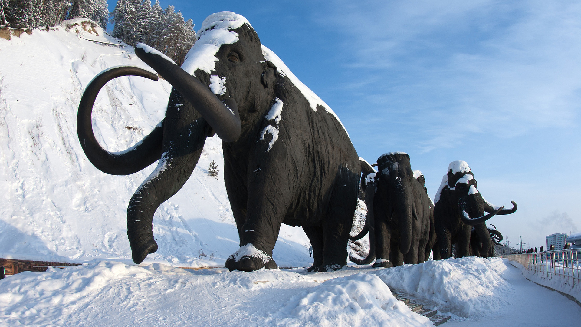 “I have been to Yugra many times. I was sworn in as a Siberian in a cedar forest,” producer Andrey Suleikov writes in the preface to a collection of legends called Yugra. It’s My Land . “I tasted lingonberries in the cold and could not tell whether the berries were coated in sugar or ice. I also enjoyed outdoor hot springs while taking a traditional Siberian bath."  Fuel pumping stations Sounds more like time travel than a present-day tourist trip, doesn’t it? But that is what Yugra is like: a fusion between prehistoric things like mammoths and modernity, which has brought oil, gas and new buildings. Even the region’s official name (which is quite long: the Khanty-Mansi Autonomous Area – Yugra) combines the present with the past.  Tying a ribbon is a national tradition There is a beautiful legend about Yugra’s origins. In one very bright, warm and sunny city, twins of unprecedented beauty were born: a brother named Yug and a sister named Ra. At first, they grew up like ordinary small children, but with age they began to argue and fight, so much so that when they did flames flared up around them. The townspeople were afraid that they would burn everything down, so they exiled Yug and Ra to a remote northern land covered with ice and snow. The brother and sister illuminated this land with their light and made it warm so that people could come here to live. Yug and Ra stopped fighting and began living together in harmony. Since then, this northern land has been called Yugra. When you look at the map, it may seem that Khanty-Mansiysk is located almost in the middle of Russia. However, the climate here is similar to regions of the Far North. In winter, the temperature here drops to below -40 degrees Celsius. We asked local residents and people who know this region well to tell us more about it and to share some tips for tourists who come to visit. Why should a foreigner visit Khanty-Mansiysk?“If you want to feel the coldness and colors of Russian winter, then you should definitely stop by in our small cozy town,” says a local tattoo artist, Semyon Chepurnoy.  A Khanty man in a traditional dress Yevgeny Zinovyev, a journalist and the former editor-in-chief of a local media outlet, says that Khanty-Mansiysk provides the opportunity to experience a real and not touristy part of Russia. “In winter, there are frosts, snowdrifts and wind. In summer, heat, midges and bears. At any time of the year, you can experience the everyday life and customs of the indigenous peoples: the Khanty and Mansi. And of course, in Khanty-Mansiysk you can get to know the backbone of modern Russia – its oil and gas sector." “We have unique scenery here. Khanty-Mansiysk is located on seven hills and is surrounded by the taiga. There are a lot of fish in the rivers, and a lot of mushrooms, berries and pine nuts in the forests surrounding the city,” says local insurance company employee Sergey Yankovich.  View of the city and the Irtysh River The harsh climate of the region influences how local residents relate to visitors. “Residents of the city are very good-natured and welcoming and are always ready to offer help in any situation, even to a stranger, because in the north, there is an unspoken rule: If you see that a person is in distress, be sure to help them, because tomorrow, it may be you in their place. The harsh climate and surrounding scenery leave no room for error, especially in winter,” Sergey says. Things to see/do/taste in Khanty-Mansiysk Mammoths at the Archeopark According to Irina Pudova, a local resident and the author of a collection of legends called Yugra: It’s My land , the first thing to do in Khanty-Mansiysk is to see the local mammoths. Seven life-size bronze prehistoric animals "roam" the area near Samarovsky Hill on the grounds of the Archeopark complex. Here you will also find a prehistoric bison, a pack of wolves, a cave bear, two woolly rhinos and prehistoric people themselves.  Sculptures of bisons at the Archeopark cultural and tourist complex “Then you could get something to eat,” Irina advises. “The thing to do is to go to any local restaurant of Siberian cuisine and ask for muksun. It is a valuable freshwater fish of the salmon family, which is highly prized by locals and tourists alike.” Khanty-Mansiysk is a relatively new city and only received this status in 1950. Soo oil was discovered in the region, prompting a dramatic push in its development. Prior to that, there were just Siberian settlements built by Russia in the late 16th century. Irina is impressed that a modern city was built in such harsh conditions.  The Church of the Protection of the Holy Virgin “Cultural objects, squares, houses - all this is unique. And everything is new, there is nothing very ancient here. Except for mammoths!” she says. In addition to the Archeopark mentioned above, Yevgeny Zinovyev’s list of favorite places in the city includes the Museum of Geology, Oil and Gas, along with the Museum of Nature and Man and the centuries-old cedars in the Samarovsky Chugas natural park. He recommends checking out the views from the observation deck near the Monument to the Explorers of the Yugra Land and paying a visit to a local bathhouse.  'Red Dragon' bridge over the Irtysh River Yevgeny also provided us a checklist of culinary delights that anyone visiting Khanty-Mansiysk should be sure to try:
Sergey Yankovich recommends visiting the open-air ethnographic museum Torum Maa, which means "Sacred Land" in Mansi. “There you can get acquainted with the history of the city and the district, as well as with the life of the indigenous peoples of the Khanty and Mansi, who belong to the Finno-Ugric group,” Sergey says.  Torum Maa ethnic center In addition, he advises anyone who comes to Khanty-Mansiysk to visit the spot where the Ob and Irtysh rivers meet, pay a visit to Misne Hotel’s restaurant and taste traditional dishes there, as well as dishes prepared by local fishermen and hunters while in the taiga. According to Semyon Chepurnoy, the Valley of Streams natural park is another must for any visitor. It is one of local residents’ favorite recreation areas, where you can stroll along a dedicated footpath offering stunning views of the city. Semyon also advises trying pancakes at the GoodFood chain of cafes. What are the best souvenirs?“We all love something mystical and supernatural. There is a strong culture of shamanism here, so I think it’s cool to take with you some local amulets charged by a shaman—a bear claw or a pendant made of beads and deerskin,” says Irina Pudova.  A Khanty woman in the traditional dress selling souvenirs Sergey Yankovich advises that authentic souvenirs can be found at the Crafts Center on Roznina Street. “There you can also see and even try on the national costumes of the Khanty and Mansi and try to solve traditional puzzles that representatives of the indigenous peoples made for their children.” According to Yevgeny Zinovyev, the best souvenirs are Khanty and Mansi amulets, clothes, jewelry, as well as traditional local treats such as muksun, wild berries, pine nuts and venison.  Cowberry bush For his part, Semyon Chepurnoy recommends bringing away memories and photographs as well as a little bit of Siberian Frost ❄. If using any of Russia Beyond's content, partly or in full, always provide an active hyperlink to the original material. to our newsletter! Get the week's best stories straight to your inbox
This website uses cookies. Click here to find out more.  Share × Scan the QR code and open PeakVisor on your phone ❤ Wishlist ×See all region register, peakvisor app, khanty-mansiysk autonomous okrug – ugra. Welcome to the land of sheer silent whiteness. Its vast expanses are filled with fresh Arctic air, howling winds, and the spirit of true adventure. Come with us to the lands of the ancient Khanty and Mansi tribes that survived in this harsh climate of the Nether-Polar Urals . See the mountains that defy any logical or geological reason for their existence. Experience the wonders of this sparsely populated land where you can hardly see a human trace. Welcome to Yugra! Flora & FaunaWater resources, landmarks and tourism, major mountains, mount narodnaya, mount zaschita, mount neroyka, the pyramid mountain, samarovskaya mountain, ski and sports facilities, protected sites, reserves, national and natural parks, rivers and lakes, major cities, khanty-mansiysk. The Khanty-Mansiysk Autonomous Area – Yugra (KhMAO) is located in the central part of the West Siberian Plain, stretching from west to east from the Ural Range to the Ob-Yenisei Watershed. The vast areas of this plain, as well as the Lower Priob region, are considered one of the most recently inhabited areas.  The Khanty-Mansiysk Autonomous Area (KhMAO) was established in 1930. Its name comes from two main northern indigenous peoples – the Khanty and the Mansi. From 1944 it was legally part of the Tyumen Region , but in 1993 the Area received autonomy and became a full-fledged territorial entity of the Russian Federation. It is a part of the Urals Federal District. The administrative centre is the city of Khanty-Mansiysk , whereas the largest city is Surgut. The word Yugra was introduced to the name of the Khanty-Mansiysk Autonomous Area in 2003 to pay tribute to the old name used by the locals to call the territories lying beyond the North Urals. The KhMAO borders the Komi Republic in the north-west, the Yamalo-Nenets Autonomous District in the north, the Krasnoyarsk Area and the Tomsk Region in the east and south-east, the Tyumen Region in the south and the Sverdlovsk Region in the south-west. The area of the territory is 534,801 sq.km, the length from north to south is 800 km, from west to east is 1400 km. The population of this huge territory is 1,674,676 people as of 2020, which is the same amount as people living in Barcelona or Munich.  The main part of the territory is a huge, poorly dissected plain where absolute elevation marks rarely exceed 200 meters above sea level. The western part of the KhMAO territory is characterized by low and middle mountainous terrains with some Alpine relief featured in the Subpolar Urals. Here are ridges and spurs of the mountain system of the North Urals and the Subpolar Urals. The maximum absolute elevations are on the border with the Komi Republic . Mount Narodnaya (1,895m) is the highest peak. More than 800 species of higher plants grow in the Khanty-Mansi Autonomous Area . Almost the entire territory is covered by taiga forests that occupy about 52% of the area. Spruce, fir, pine, cedar, larch, birch, alder grow here. In the northern parts of the area, the composition of the vegetation is greatly influenced by perennial permafrost. Light lichen grasslands which are used as deer pastures are widespread there. Tundra dominates in the mountainous and hilly areas. River floodplains and lowlands are characterized by meadow vegetation, the so-called water meadows. High floodplains of large rivers are mainly covered with woods that mainly feature willows, birches and aspens. Forests and swamps are rich in berries and various valuable plants, most of which are used in traditional indigenous medicine.  The animal world is typical for the Russian taiga zone. There are 369 species of vertebrates. Mammals are represented by 60 species (28 of them are commercial species). The most common and valuable of them are wild reindeer, elk, fox, sable, fox, squirrel, marten, ermine, Siberian weasel, polecat, mink, weasel, otter, hare and others. Wolverine and West Siberian river beaver are included in the Red Book of Russia. There are 256 bird species in the region, including 206 sedentary and nesting species. Some rare bird species are listed in the Red Book. There are 42 species of fish in rivers and lakes. Of these, 19 species are commercial, among them are starlet sturgeon, lelema, muksun (whitefish), pelyad, chir, lake herring, wader, tugun, freshwater cod, pike, ide, roach, bream, fir, perch, ruff, golden and silver crucian carp, carp (carp is grown in the cooling ponds of the Surgutskaya and Nizhnevartovskaya hydroelectric plants). Sturgeon is listed in the Red Book. There is an abundance of mosquitoes and gnats in the area, the greatest activity of which is in the second half of summer.  Yugra can boast of over 2 thousand large and small rivers, the total length of which is 172,000 km. The main rivers are the Ob (3,650 km), the Irtysh (3,580 km). These are some of the largest rivers in Russia. Other significant rivers include the tributaries of the Ob (the Vakh, Agan, Tromyogan, Bolshoy Yugan, Lyamin, Pim, Bolshoy Salym, Nazym, Severnaya Sosva, Kazym rivers), the tributary of the Irtysh (the Konda River) and the Sogom River. Ten rivers are over 500 km long. All the Yugra rivers with the exception of the rivers in the Ural part of the region are characterized by rather slow currents, gentle slopes, some surge wave phenomena, spring and summer floods. The Ob River basin extends over a distance of 700-200 km from the mouths of its tributaries. Such abundance of water facilitates the appearance of floodplain swamps and seasonal lakes. The region's swamps are predominantly of the upper and transitional type. Those water basins occupy about a third of the region. About 290,000 lakes with the area of more than 1 ha are surrounded by swamps and forests. The largest lakes are Tursuntsky Tuman, Levushinsky Tuman, Vandemtor and Trmemtor. The deepest lakes are Kintus (48 m) and Syrky Sor (42 m). However, most of the lakes (about 90%) are modest and quite small and have no surface runoff. The area is rich in resources of fresh, mineral and thermal underground waters, which are still insignificantly used.  The climate is moderately continental. Winters are harsh, snowy and long, and summers are short and relatively warm. The territory is protected from the west by the Ural Mountains but its openness from the north has a significant impact on the climate formation because cold air masses from the Arctic freely penetrate the area. The flat character of the terrain with a large number of rivers, lakes and swamps also has its impact. Most of the precipitation falls during the warm seasons. But even with a small amount of precipitation, their evaporation is very low, which as a result contributes to the formation of the zone of excessive moisture throughout the Yugra. The snow cover is stable from late October to early May, its height varies from 50 to 80 cm. The region is characterized by a rapid change of weather conditions, especially in transitional seasons (autumn and spring), as well as during the day. Late spring and early autumn frosts are rather frequent and can happen even until mid-June. Average January temperatures range from -18ºC to -24ºC (0 F to -11 F) and can reach -60ºC to -62ºC (-76 F to -80 F) when the northern cold air masses break through. The average temperature in July, the warmest month of the year, ranges from +15ºC to +20ºC (+59 F to +68 F) and on very rare days can reach a maximum temperature of +36ºC (+97 F). The prevailing wind direction is north in summer and south in winter. The weather in the mountains is quite changeable and cool even in summer. The best time to visit the region's mountains is between July and mid-August. The Yugra of the Khanty-Mansi Autonomous Area has a huge natural resource potential. These are oil and gas deposits, forests, gold and iron ore deposits, as well as bauxites, copper, zinc, lead, niobium, tantalum, brown and hard coal deposits, rock crystal, quartz and piezo quartz, peat deposits, etc. The region has plenty of natural resources. In terms of natural gas reserves, the Yugra ranks second in the Russian Federation after the Yamalo-Nenets Autonomous District . The industry is dominated by oil and gas production, power generation and processing industries, including woodworking except for pulp and paper production.  The Khanty-Mansi area has very developed tourism of all kinds. There is a modern infrastructure for cultural exploration as well as for active recreation. Fans of sports and eco-friendly tourism will be able to conquer majestic mountains and raft down picturesque rivers, enjoy the beauty of nature in nature reserves and natural parks. The hills and mountains of this area open up endless opportunities for skiing and snowboarding. The mountainous part of the Subpolar Urals located on the territory of the Khanty-Mansi Autonomous Area is very beautiful. The highest peaks of the Ural Mountains are situated here. Being the highest point of the whole Urals, Mount Narodnaya (1,895 m), also known as Naroda and Poenurr and translated as People's Mountain is territorially situated in the Subpolar Urals, on the border of the Yugra Area and the Komi Republic . It is the highest point in European Russia outside the Caucasus. This leads to its large topographic prominence of 1,772 metres (5,814 ft).  The top of the mountain is half a kilometre from the border towards Yugra. As for the name of the mountain, scientists could not come to a common opinion for a long time, so there are two versions. According to one version, in the Soviet years, an expedition of pioneers gave the mountain a name in honour of the Soviet people - Narodnaya (the stress is on the second syllable). According to the other version, even before the arrival of the first Soviet tourists, the peak was named after the River Naroda (the stress is on the first syllable) flowing at the foot of the mountain. The Nenets peoples called the River Naroda Naro, which means a thicket or a dense forest, and the Mansi peoples called it Poengurr or Poen-urr, which translates as the top, or head. The maps used to refer to it as Mount Naroda or Mount Naroda-Iz. Nowadays, it appears everywhere as Narodnaya. In the 1980s, someone set a bust of Lenin on the top of the mountain. Its remains can be found there to this day. There is one more symbolic relic there – some Orthodox believers erected a worship cross on top of Mount Narodnaya after a Procession of the Cross. The slopes of the mountain are steeper in the north-east and south-west and there are many steep rocks on them. The south-eastern and northern parts of the mountain are more gentle but they are also covered with scree. Be vigilant and careful when climbing! On the slopes of the mountain, there are many not only boulders but also caverns filled with clear water as well as ice. There are glaciers and snowfields. From the north-eastern part of the mountain, you can observe Lake Blue near which tourists and travellers like to make bivouacs.  Mesmerizing with its beauty and inaccessibility, it attracts many tourists and fans of active recreation. This majestic mountain is quite remote from the settlements, so getting to it is not an easy task. The mountain is located in the Yugyd Va National Park , so it is necessary to register in advance and get a visit permit from the park administration. How to get to the park administration and get a permit, read the article on the Yugyd Va National Park . Mountain Zaschita (1,808 m) is the second-highest peak in the Ural Mountains, after Mount Narodnaya . Mysteriously, the name of the mountain, which roughly translates as Defense or Protection Mount, does not correlate in any way with the Mansi names of the nearby mountains and rivers. The origin of the name is unknown. There are some speculations but we will consider just one of them. On the map of the Northern Urals which was made by the Hungarian researcher Reguli the closest peak to Mount Narodnaya was called gnetying olu. Its location coincides with that of the present-day Mount Zaschita . The name gnetying olu in the Mansi can be deciphered as a mountain on which there is some help from ice. The mountain is believed to protect deer grazing on glaciers from mosquitoes. So, early topographers called the mountain more briefly – Mount Defense. Indeed, the slopes of this mountain are covered with a lot of snow and glaciers (the Yugra, Naroda, Kosyu, Hobyu glaciers and others). And it is here that the Mansi shepherds bring their deer which can rest on glaciers and snow. Summarizing all the above, we can say that Zaschita Mount is to some extent protection for deer from mosquitoes. The very name Zaschita appeared on maps with the beginning of hiking tours in the Subpolar Urals. Mount Neroyka (1,645 m) is 100 km from Neroyka village, the closest tourist base to this peak. In the 1950s, people who were engaged in quartz mining near the mountain worked and lived in this base. Later, a gravel road was built from the village of Saranpaul to the mountain for large-scale development of the quartz deposit. In recent years, the road has not been much used and is practically not cleaned from snow in winter. There has been a plant built 20 km down from the mountain for primary processing of quartz with the use of nanotechnologies. There is an annual big camping event near the mountain. It is organized by the Tourism Department of the Khanty-Mansi Autonomous Area. You can have a 1-hour helicopter ride to the mountain from the village of Saranpaul. Should you wish to fly from the city of Khanty-Mansiysk , be prepared to fly over the taiga for 2.5-3 hours.  Quite inquisitive tourists happened to discover, by a lucky chance, a Pyramid similar to that of Cheops but four times bigger. It is located on the territory of the Narodo-Ityinsky Ridge. The closest to the pyramid is the village of Saranpaul. The sizes of the found pyramid are as follows: the height is 774 m, in comparison to the Egyptian pyramid which is 147 m; the length of a lateral edge is 230 m whereas the Egyptian pyramid is 1 km. The pyramid is located precisely according to the cardinal directions, there is not a single degree deviation at that. The origin of the pyramid is unknown, scientists are still making assumptions. No traces of human activity were found near the pyramid. The only way to get here at this time is by helicopter. Samarovskaya Mountain is another wonder that is baffling many people. It is dividing the city of Khanty-Mansiysk into northern and southern parts. Few now living residents know that in the old days the highest part of the modern city used to bear a plural name of the Samarovsky Mountains among which there were Mount Palenina, Komissarskaya, Miroslavskaya, Filinova, and Romanova. Originally, there was a village called Samarovo amidst these mountains. Until now, many issues bewilder both residents and scientists. How could a mountain form in the middle of the West Siberian Plain? What is inside it? Won't the weight of the buildings erected on the top of the mountain affect its height? The uniqueness of Samarovskaya Mountain is that it consists of numerous large stones, boulders, rocks that are absolutely foreign to this area. Scientists have not yet come to a consensus on the mountain’s origin.  The Yugra is very famous for its ski resorts, the main of which are:
The far-away lands of the Yugra are the blessed sanctuaries for many animals as the area is rather hostile to a human There are reserves, natural parks, wildlife sanctuaries here that aim to protect the national treasures of the lands. Having visited these regions once, you would crave for coming back again and again to feel that unique sense of unity with nature, to forget about the urban fuss and and hustles whatsoever. The harsh but beautiful nature of this extraordinary area leaves an indelible trace in the soul of every person.  On the territory of the district there are 25 specially protected natural areas, the most famous of them are:
These reserves and natural parks offer tourists their own excursion programs to make visiting their territory much more enjoyable and educational. The Samarovsky Chugas Nature Park is located in the center of Khanty-Mansiysk , on a small hill between the Ob and Irtysh rivers. The territory of the Siberian Sloping Hills (Uvaly) natural park is 350 km away from the city of Khanty-Mansiysk . You can get there by helicopter or by plane. The office of the park is located at 7a Pionerskaya Street, Nizhnevartovsk. The Kondinskie Lakes Natural Park is located 380 km from Khanty-Mansiysk . Half of the park is covered with swamps, but there is also a recreational area. There you can rest, swim, do some amateur fishing, picking berries (cowberries, cranberries) and mushrooms is permitted. There is only one independent walking route here, it runs for 3 km in the deep forest. It is a cool place for kids since the park is equipped with sports grounds, a pool and a small zoo where the kids can interact with brown bear cubs. What else, try the TaiPark, it is a rope course running at the height of 2.5 meters, having 15 stages, the full length is 125 meters. There is an opportunity to order water walking tours in the town of Sovetsky, which can be reached by train from Khanty-Mansiysk .  The Numto Nature Park is located almost in the center of the West Siberian Plain, in the Beloyarsk district of the Khanty-Mansi Autonomous Area, 300 km from the city of Surgut and 200 km from the town of Beloyarsk. It is located on the border of Yugra and Yamalo-Nenets Autonomous Area. The administration of the park is located at 2, Beloyarsky micro-district, 4a. The territory of the natural park is a treasure trove of archaeological and ethnocultural monuments. As of today, there have been discovered 20 architectural monuments, including fortified and not fortified settlements, places of worship abandoned by the peoples who lived here from the Stone Age to almost the present day. Researchers have also found 65 monuments of ethnic value, the main of which are worship objects, sacred places and cemeteries. The Malaya Sosva Reserve includes several subordinated territories and sanctuaries, including Lake Ranghe-Tour. The reserve offers a 4-km walking guided route that gets the visitors introduced to the typical features and characteristics of flora and fauna of the region. The route is called Bear Trail and you can spot bears there (don’t come close though, we’ve already written how to behave if you meet a bear in the wild). Also, you will see the River Malaya Sosva, some marshes, ancient cultural monuments and other nice sights. Permission to visit the reserve can be obtained from the administration of the reserve at Lenina Str. 46, town Sovetskiy. As to the Yugan Nature Reserve , it is inaccessible to common hikers who are afraid of flying since there are no roads to it. The only way to get there is taking a helicopter ride. You also must obtain a permit in the administration of the reserve, go accompanied by employees of the reserve, and only on special transport of the reserve (motorboat, snowmobile). The central manor of the Reserve and the administration are located in the village of Ugut. To get to this village, you should first go to the town of Surgut, then go to the town of Pyt-Yakh, and from it there is a road to the village of Ugut. It is about 100 km from Ugut to the southern border of the reserve i, and another 25 km to the nearest cordon. The administration works from Monday to Friday. You can request a permit via mail at [email protected] , order a guided tour at [email protected]  The Yugra lands are heaven for water sports aficionados. They can have some awesome fishing or go rafting along such rivers as: the river Naroda, the Deep Sabun, etc. The Naroda River is 140 km long. It is the left tributary of the Manya River located in the Ob River basin. The river has its origin on the south-western slope of Mount Narodnaya . It is a mountain-taiga river with rapids, swifts, numerous rolls, which attracts interest among water tourists. However, it is usually not rafted very often. The Deep Sabun River flows through the territory of the Siberian Sloping Hills Nature Park. The park has developed multi-day water routes. It is possible to raft along the river in summer and to go skiing along it in winter. The Kondinskie Lakes are a system of lakes along the left bank of the Konda River. The largest lake is the Arantur, with pine forests on the northern side and sandy beaches well equipped for a nice relaxing me-time. The water heats up well in summer. The small river Okunevaya and the river Maly Akh flow into the lake. The Maly Akh comes in on the west side and connects lake Arantur with Lake Pon-Tour. This lake is the richest in fish, and there is also a parking lot for fishermen here. The streams connect Pon-Tour with small lakes Krugloe and Lopukhovoye. When you look at Lopukhovoe lake, you feel as if you have found yourself in a fabulous place: more than half of its surface is covered with white lilies, as well as yellow flowers of the water-beans. Then the river Big Akh, which flows into the river Konda, connects all the lakes into a single system. Along the river there are many archeological monuments such as forts and settlements which have paths to them. The southernmost lake of the park is Ranghe-Tour.  Yugra is not the easiest destination and not the most accessible, but the effort is well worth it. You should first get to the capital of Khanty-Mansiysk Autonomous Area – the city of Khanty-Mansiysk either by air or by train. Khanty-Mansiysk is based on the premises of the former village Samarovo founded in 1582. It used to be the territory of the Khanty people and a pit stop for coachmen who rode their wagons across the country. The village was founded by Russian Count Samara, thus the name Samarovo. The modern city actually began to develop in 1930 because amidst the Siberian taiga there finally started to appear stone houses on the high bank of the Irtysh River. In 1940, the village was renamed into Khanty-Mansiysk by the name of the peoples living on this territory – the Khanty and the Mansi, and in 1950 it received the status of a town.  The city has several attractions. Mount Samarovskaya is probably the biggest natural and scientific wonder. It divides the city in two parts and causes many concerns for urban developers who always wonder whether this mountain can move making the buildings slide or even sink in. Another beauty is the century-old cedar grove that is within the city limits. The grove is a part of the natural park Samarovsky Chugas. The word chugas in the language of the Khanty means a lonely hill in the low river floodplain.  The park is one of the main attractions of the city, it hosts an open-air ethnographic museum called the Torum Maa, a cultural and tourist complex called Archaeopark, a biathlon center. Kids and adults, nature lovers and fans of culture love this place dearly. A memorial sign to Yugra's discoverers is installed on top of the Samarovsky Chugas. It is a tall stele pyramid divided into three portions. On the lower level, there is a restaurant, on the second level is a small museum, and on the third level there is an observation deck, 40 m above the ground, with a magnificent view of the Irtysh River and the river port. The pyramid is decorated by the bas-relief depicting the discoverers of the region, from the 16th-century Count Samara to the geologists of the 20th century. Another trademark of Khanty-Mansiysk is the State Museum of Nature and Man. The museum hosts a gallery and a workshop of a famous artist G. Rayshev. The city has a lot of small monuments generously spread around the city. There is the Khanty family resting on a camp, this monument is near the airport building. You can take a pic at the Golden Tambourine located at the intersection of Gagarin Street and Mira Street. Connoisseurs of culture should also visit the Sun – the Theatre of Ob-Ugrian Peoples, it is the world's first professional theatre of Khanty and Mansi peoples. And if you are travelling with kids, the Khanty-Mansiysk Puppet Theatre is a must-visit. In the period from May to October, you can take a boat ride to the confluence of two rivers – the Ob and the Irtysh. Yugra Service Co. operates such cruises, you can find more information locally at their address Tobolsk Trakt street 4, Khanty-Mansiysk .  Explore Khanty-Mansiysk Autonomous Okrug – Ugra with the PeakVisor 3D Map and identify its summits . PeakVisor Hiking MapsBe a superhero of outdoor navigation with state-of-the-art 3D maps and mountain identification in the palm of your hand!  | |||||||||||||||||||||||||||||||||||||||||||||||||||||||||||||||||||||||||||||||||||||||||||||||||||||||||
IMAGES
COMMENTS
Ever wanted to know what it feels like to sail on land? well now is your chance.Pendine Sands offers six miles of uninterrupted, firm, flat beach, the ideal ...
Description of Half Day Sand Yachting Pendine. Come along and have a go at Sand Yachting, an ingenious activity done on beaches when the tide is out that is a mix of buggies and sailing! Shaggy Sheep Wales offers this activity and lessons in Pendine, Carmarthenshire on one of the biggest beaches in Wales!
Malcolm Campbell set the world land speed record here in Blue Bird in 1924 and again in Blue Bird II in 1927. His grandson, Don Wales', set the electric land speed course record in 2000. And in May 2019, a Porsche 911 set a new course record of 338.50km/h. The areas you can drive on are limited now, but if you're a petrolhead, Pendine Sands ...
The Museum's first floor purpose-built function space features a huge floor to ceiling window with unparalleled views down Pendine's seven-mile sands. The 64m² room can be set out in boardroom style (20 pax) or theatre style (50 pax), with independent electrical blinds that easily adapt it for video conferencing, presentations, or live ...
Pendine sands have a nearly 100-year history of setting land speed records; beginning in the 1920s with Sir Malcom Campbell and his car 'Blue Bird' to more recently the actor Idris Elba taking on Campbell's 'Flying Mile' record in a Bentley Continental GT Speed in 2015. This amazing stretch of sand has seen many land-speed records set and ...
Land Yachting (16+ years) £60 per person. As the only provider based in South West Wales, this unique weekend activity at Pendine Sands offers an exhilarating land sailing experience. Famous for its motorised speed records the beach provides the ideal venue with endless flat sands and panoramic views of Carmarthen Bay and beyond.
The first person to use Pendine Sands for a world land speed record attempt was Malcolm Campbell. On September 25, 1924 he set a world land speed record of 146.16 mph (235.22 km/h) on Pendine Sands in his Sunbeam 350HP car Blue Bird. Four other record breaking runs were made on Pendine Sands between 1924 and 1927; two more by Campbell, and two ...
Carmarthenshire Land Sailing Club, was formed in 2004 in order to allow Landsailing use of Pembrey Sands and Pendine Sands, in South Wales. History [ edit ] The Club, was created from the now defunct, Pendine Wind Sports Club and the Cefn Sidan Landyachting Club, in order to provide a single organisation to allow controlled use of the beaches ...
Pendine Sands (Welsh: Traeth Pentywyn) is a 7-mile (11 km) ... The first person to use Pendine Sands for a world land speed record attempt was Malcolm Campbell. On 25 September 1924 he set a world land speed record of 146.16 mph (235.22 km/h) on Pendine Sands in his Sunbeam 350HP car Blue Bird.
Welcome TO Carmarthenshire Land Sailing Club. CLSC exists to promote and maintain access for land sailing, including land traction kiting activities, on Cefn Sidan (Pembrey) and Pendine beaches. As part of the access agreement, everyone taking part in these activities on these beaches must be a member of CLSC. Our goal is to promote and enjoy ...
Pendine Museum of Speed is still the summer home of the restored 'Babs', which Parry-Thomas drove to a land speed record on the sands in 1926 and in which he died in a subsequent failed attempt the following year. ... land-sailing, kite buggying and even a test site for the latest Thrust SSC world land speed record attempt car. Further ...
Pendine sands. Pendine Sands is a flat out seven miles of shoreline, and as it happens - ideal conditions to set the land speed record. The early 20th century saw a fierce battle to the top that culminated in the Welsh Driver J.G. Parry's death in 1927. His car (Babs) was excavated from the sands and is now housed in the nearby 'Museum of ...
History of Pendine Sands. For a short period in its history Pendine was at the centre of attempts at the World Land Speed Record. Between 1924 and 1927, the record was chased, won and held here. The sands were seven miles long. They were hard and flat.
Pendine Sands . Surf Session . Learn how to negotiate the surf and catch a wave by Bodyboarding and then advancing to a surfboard. Read more . On-site . ... April 2023 Coasteering We booked Coasteering through Morfa Adventure in Pendine for a group of 15 lads and 2 adults from U14's Rugby Group at the end of April 2023. From enquiry with ...
In March of that year Parry-Thomas became the first person to be killed in a world land speed record attempt when he crashed, in Babs, on Pendine Sands at about 170 miles per hour. The wreck of ...
CAPITAL: Khanty-Mansiysk (founded in 1582, population 101,000 as of 2019) Watch video from the capital of Yugra here. AREA: 535,000 km2, rank 9th in the country. POPULATION & NATIONALITIES: 1,700,000 as of 2019, national composition: Russian 68%, Tatar 7,6%, Ukrainian 6%, Bashkir 2,5% the indigenous population (Khanty, Mansi, and Nenets) is 2,2 ...
Scotland is a land of real diversity. Revel in the vibrancy of Edinburgh and Glasgow or enjoy solidarity on the peaceful islands of Skye or Lewis. ... caving, coasteering, gorge walking, mountain biking and land yachting. Take in beautiful Pendine from horseback with Marros Riding Centre, offering beach and woodland rides for individuals ...
The ancient land of Yugra, now home to the modern city of Khanty-Mansiysk, is filled with the memory of prehistoric people and extinct cave animals. Oil was discovered here in more recent times ...
Khanty-Mansi Autonomous Okrug — Yugra [a], commonly shortened to Khantia-Mansia, is a federal subject of Russia (an autonomous okrug of Tyumen Oblast).It has a population of 1,532,243 as of the 2010 Census. [4] Its administrative center is located at Khanty-Mansiysk.. The peoples native to the region are the Khanty and the Mansi, known collectively as Ob-Ugric peoples, but today the two ...
The Khanty-Mansiysk Autonomous Area (KhMAO) was established in 1930. Its name comes from two main northern indigenous peoples - the Khanty and the Mansi. From 1944 it was legally part of the Tyumen Region, but in 1993 the Area received autonomy and became a full-fledged territorial entity of the Russian Federation.